A long time ago, when mammoths and sabre-toothed cats roamed the earth, a giant pine forest covered a large portion of Texas (and other Southern states). But over the millennia, the climate became drier, people chopped down trees, and the once-giant forest ceased to be. Parts of it still remain, though. The expansive Piney Woods of East Texas is one remnant of that forest.
One hundred miles away from the Piney Woods, on the edge of the dry Hill Country, another, more isolated, stand of that primeval giant forest also somehow survived. That isolated forest – separated thousands of years ago from the Piney Woods by the movements of a massive glacier – is the Lost Pines, the “westernmost stand of loblolly pine trees in the United States.” When Bastrop State Park was built, thousands of acres of the Lost Pines were located within its confines.
Bastrop State Park burned down in 2011.
And when the park flooded in 2015, the earthen dam impounding Bastrop State Park Lake failed, emptying that lake.
What happens after the destruction of a pine forest by fire and flood? What is left to see?
Mom and I found out the answers to those questions in April 2018, when we went hiking at Bastrop State Park.
The Beginning of the Day
Bastrop State Park’s website advertised a guided hike on Sunday morning at 10 a.m. Since we had gotten lost AND scared during our two previous hikes (at two different parks), we believed that the presence of an experienced guide would allay our fears and maybe teach us a few things. We looked forward to a relaxing, educational morning.
Unfortunately, the advertisement had been a computer error. There was no scheduled guided hike for us to go on that morning. We were going to be on our own.
Looking at the trails map, we made a plan. We decided to drive to the parking lot by the Post Oak Spur, walk the length of the Post Oak Spur to the Scenic Overlook Trail, follow that Scenic Overlook Trail until it hit the paved road, and then walk along the road back to the car. Basically, we were going to make our own little 2-mile loop that would enable us to see a great sample of the park. It was a good plan.
Until we got lost.

Less than 5 minutes into our walk on the Post Oak Spur, we saw a woodpecker. I love woodpeckers. It was a strong start to the day!

Mom and I were awed by the landscape. The vast scale and scope of the devastation from years ago could still be plainly seen. Burned out husks of dead trees jutted out from the land. Many stumps and logs lay on the ground, charred. A smokey smell permeated the air, perhaps from a recent controlled burn, perhaps not. The area felt wild but injured, with land previously covered with lush greenery now exposed like a wound.

Wounds do heal. The forest was changed by the fire, perhaps diminished, but it was not vanquished.
Young trees thrived without the presence of older ones choking them off from sunlight.

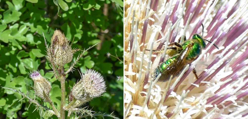
Evil-looking weeds flourished, with pollinators scurrying about.
The Post Oak Spur is a well-maintained dirt path a little less than a half-mile long, so we soon reached the Scenic Overlook Trail. Shortly thereafter, we came upon the turnoff for the Pine Warbler Trail.

We didn’t take the Pine Warbler Trail, instead keeping to our planned route (or what we thought was our planned route).
We reached a point that looked scenic overlook-esque, so we thought we were on the right track.

After resting for a few minutes at that not-really-a-scenic-overlook, we continued our journey down the path, which soon transformed into a long series of steps.

Dew berries grew along the side of the path. Mindful of the instructions not to eat anything growing inside of state parks – even the delicious things – we left them alone.
At the top of the steps, the land was more open, with numerous older trees having been toppled over but not replaced by new ones, their cones still clinging to dead branches. There were a lot of flowers.

Not long after reaching the top of those steps, we arrived at the road. We felt good after the walk, but we were eager to get back to the car.
After going down the paved road for a little while, there was this conversation:
“Shouldn’t we be at the car by now?” – Mom
“Nah, we just haven’t gone far enough yet. It’ll be just up the road here, after this bend in the road.” – Me
Rounding the bend, we came to a T-intersection that should not have been there. We had taken a wrong turn, a long time ago. Our car was not close to us at all. We had been walking for two hours, and we were out of water.
“You got us lost again!” – Mom
“No I didn’t. I know exactly where we are now. I was previously just temporarily mistaken about our location.” – Me
“You got us lost again.” – Mom
I sure had.

We had taken the wrong path at a fork in the Scenic Overlook Trail, going down the Farkleberry Spur instead of staying on the Scenic Overlook Trail.
There was nothing to do but backtrack the way we had come. Mom was not very happy with me or my map reading skills (or lack thereof). Nevertheless, once we had made it back to the Scenic Overlook Trail, we decided to continue with our planned walk and complete the loop we had devised rather than just return to our car via the Post Oak Spur we had already hiked.
I’m glad we did.
We saw ferns.


We explored a creek bed for endangered toads. We didn’t find any.
We observed many different kinds of insects.


We saw the scenic overlook marked as the #4 Point of Interest on the map.


The Scenic Overlook Trail was slightly challenging. There were elevation changes, steep-ish paths with loose gravel, and switchbacks that we weren’t sure would ever end. The chilly morning warmed up significantly, and we got uncomfortably hot. This trail was also…kinda busy. It wasn’t overpopulated, with huge lines or crowding, but we would encounter other people every few minutes. We just never felt as isolated as we did at Fort Boggy. This had the curious effect of making us simultaneously more relaxed (because we were not as scared of wild animals) and more on-edge (because other people are annoying).
After walking about 4 miles, we (finally) completed our original planned hike (that was supposed to be around 2 miles). We were hungry, so we had a picnic lunch by the park’s playground while we plotted out our next steps.
Should we go home? We were pretty tired from the morning’s ordeal. Or should we walk another trail? Which one?
Ultimately, we decided to go see the other scenic overlook marked on the map, the #7 Point of Interest. To reach it, we would need to hike a small portion of the Lost Pines Loop and then take the Fehr’s Overlook Trace. We calculated the round trip to be around 1.2 miles.
That hike went according to plan!
The hike was not without its difficulty, though. The foliage was much denser by that path than at the other areas of the park that we had seen. Due to the overgrowth and damage to the trailhead, finding the actual trail entrance was a challenge. We were already nervous about my ability to read a map, so we weren’t certain we were on the right track until we actually reached the overlook destination. And we were continually frightened by movements in nearby bushes. It could have been something scary!

We saw a bunch of small lizards. I believe they are called whiptail lizards or racerunners. We also saw butterflies and spiders.
The hike itself was also moderately challenging. The overlook…overlooks the park. Which means that it is at a relatively higher elevation. Which meant we had to climb some more dang steps to reach it.

The view from that site was not really photogenic, generally consisting of a park road, a water tower, some trees, and a nearby highway. Nevertheless, it provided an overall sense of the vast scale of the park and how utterly unimaginably massive the fire and flooding must have been to damage it. After taking in the view, we made our way back down the trail.

Bastrop State Park is connected to Buescher State Park, located a few miles away by a paved park road. We decided to drive down that road. It was a nice drive, and the trees grew denser the closer we got to that state park. When we arrived, it looked pretty, with far less devastation than what was at Bastrop State Park, only a few miles away. We definitely looked forward to further exploring Bueshcer on our next trip.
Bastrop State Park was not conventionally pretty. Yet, I thought it was beautiful, a perfect demonstration of how life rebuilds, even after widespread destruction. I would like to go back someday, to see it what it looks like, fully recovered and transformed.


The sign at the entrance of the purple trail said 1.49 mile. I have lupus, rhuemetoid and kidney disease therefore my husband and I are very cautious on hiking trails. But after looking at the nice gravel walkway decided we would do it. (took fruit and water)Turns out the map was old and we actually walked 8 miles! Wasn’t sure I was going to make it at times, we took many breaks. When we finally landed on a road my husband took off walking for the truck to come pick me up. He ended up at a private residence and started walking back to me. A wonderful lady stopped and gave us a ride back to our truck which was on the opposite side of the park??? We made it but we both went to bed tired and sore.
LikeLike